Monitoring the Development of Invest 95L: Impacts and Predictions
Invest 95L, located near Nicaragua and Honduras, is predicted to move westward towards Belize and Yucatán, with a moderate chance of becoming Tropical Storm Nadine before landfall. There is also a separate system, Invest 94L, projected to diminish as it approaches Haiti, with no significant threat posed to Florida or the southeastern U.S. Beachgoers should be cautious of heightened tides due to King Tides.
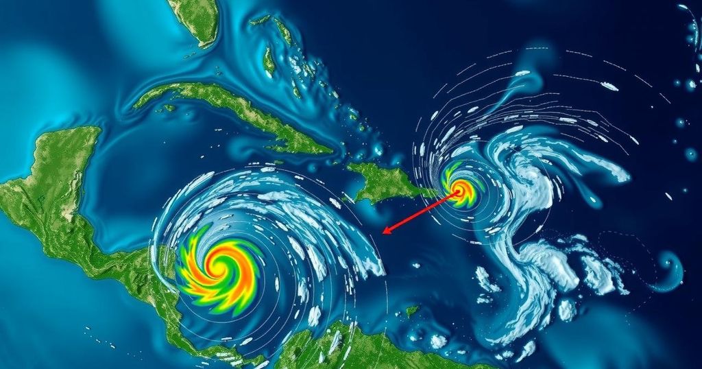
Bryan Norcross is closely monitoring the development of Invest 95L, a tropical disturbance situated near the coasts of Nicaragua and Honduras. Officially designated as Invest 95L, it is predicted to pursue a westward trajectory, remaining just offshore of the northern coast of Honduras before making landfall in Belize or Yucatán, Mexico. The National Hurricane Center has indicated that there is a moderate chance that the system could intensify into a tropical depression or, potentially, Tropical Storm Nadine, prior to its arrival onshore early tomorrow morning. As the storm approaches, the greatest winds, currently estimated at 30-35 mph, are situated north of the center of the system. Thus, regions to the north of the expected landfall point on the Yucatán Peninsula are anticipated to experience the most significant onshore winds. Residents along the northern coast of Honduras, in Belize, and in the Mexican state of Quintana Roo, particularly Chetumal, are urged to remain vigilant as the system may strengthen just before it makes landfall. The peak impacts are expected to commence overnight and continue into the following day. A cold front advancing from the north will further exacerbate breezy conditions along the coastline. Meanwhile, another tropical disturbance, tagged as Invest 94L, is projected to traverse the waters just north of Puerto Rico and the Virgin Islands today, heading toward Haiti or the southeastern Bahamas tomorrow. The National Hurricane Center projects a minimal likelihood of this system developing into a tropical depression prior to dissipating due to unfavorable upper-level winds expected by Sunday. Despite the low chance of organization, this system could cause significant rainfall across the mountainous islands, leading to potential flooding and mudslides. In terms of future impacts, there is no expected threat from either disturbance to Florida or the southeastern United States. The jet stream is forecasted to adopt a wintertime pattern across the northern Gulf of Mexico and Florida for the remainder of the month, ensuring substantial protection for the region. Furthermore, residents along the east coast of Florida should be aware of the heightened tides expected throughout the weekend, attributed to the current Hunter’s Supermoon phenomenon. The combination of these King Tides alongside strong, persistent coastal winds may lead to exacerbated tidal flooding. It is advisable to avoid driving through salty floodwaters to mitigate damage to vehicles.
Invest 95L, a tropical disturbance recently identified near the coasts of Nicaragua and Honduras, poses potential weather impacts as it moves westward toward Belize and Yucatán, Mexico. The National Hurricane Center’s assessments provide insights into the likelihood of the system developing into a more potent storm, while also detailing potential implications of a separate disturbance, Invest 94L, that may cause adverse weather conditions in nearby islands. Individuals and communities in the anticipated path of these systems are advised to remain vigilant and informed about changing conditions. Additionally, environmental phenomena like the Hunter’s Supermoon contribute to higher tidal levels, further complicating coastal weather dynamics.
In summary, the tracking of Invest 95L suggests a moderate potential for development into a tropical storm before landfall, impacting regions in Belize and the Yucatán Peninsula. Meanwhile, Invest 94L appears unlikely to strengthen but may still contribute to adverse weather conditions in its path. Public awareness and preparedness remain crucial as these systems evolve, particularly given the accompanying tidal challenges along the Florida east coast. Overall, current forecasts indicate limited risk for the southeastern United States from these disturbances, with the promise of protection from atmospheric patterns expected to persist throughout the month.
Original Source: www.foxweather.com


Post Comment