Hurricane Kirk’s Intensification and Potential Impact on Florida
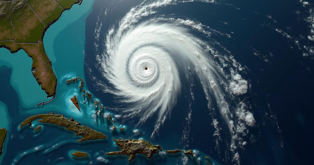
Hurricane Kirk, currently a Category 3 storm with winds of 120 mph, is expected to become a Category 4 hurricane in the coming hours. It is projected to remain primarily over the Atlantic but may impact the U.S. East Coast by Sunday. Tropical Storm Leslie is also likely to strengthen, while another system approaching Florida could bring heavy rain and flooding.
Hurricane Kirk is currently a powerful storm positioned in the central Atlantic, with maximum sustained winds recorded at 120 mph, categorizing it as a Category 3 storm. The latest projections indicate an imminent transition to a Category 4 hurricane, potentially reaching sustained winds of 140 mph within the next 24 hours. Although Kirk is anticipated to remain predominantly over the open waters of the Atlantic Ocean, there are concerns that its effects may extend to the east coast of the United States, particularly starting Sunday. Concurrently, Tropical Storm Leslie is situated to the west of Africa and is also forecasted to escalate into hurricane status. Another system approaching the Gulf of Mexico poses a risk of significant rainfall and flooding across Florida, independent of its classification as a tropical storm or hurricane. Hurricane Kirk, located approximately 1,185 miles east of the Northern Leeward Islands and 1,645 miles southwest of the Azores, is currently moving northwest at 10 mph. This movement is expected to continue, followed by a shift to a north and north-northeast trajectory at an increased speed over the weekend. Despite a recent phase of rapid intensification—where winds increased from 80 mph to 120 mph in mere hours—Kirk has temporarily halted further strengthening, according to the National Hurricane Center. As of 5 a.m. EDT, it has been noted that hurricane-force winds are extending outward up to 35 miles from its center, while tropical-storm-force winds reach up to 185 miles away. The estimated minimum central pressure for Hurricane Kirk stands at 955 mb. The National Hurricane Center has provided warnings regarding potential ocean swells from Kirk, which may elevate the risk of dangerous surf and rip currents along various regions such as the Leeward Islands, Bermuda, the Greater Antilles, and potentially the U.S. East Coast and Bahamas by the weekend. AccuWeather also noted that Kirk could impact shipping interests significantly and possesses the potential to influence weather patterns across Europe next week. In the case of Tropical Storm Leslie, it currently boasts maximum sustained winds of 40 mph and is expected to become a hurricane by early Saturday, typically moving in a slower westward motion through tonight. Leslie’s path is projected to lead it away from the Caribbean Islands, thus mitigating direct impacts on land for the time being, but it remains a concern for shipping across the Atlantic.
Hurricane Kirk’s anticipated intensification and trajectory raise questions regarding its potential effects on coastal regions of the United States, particularly Florida. The National Hurricane Center has issued advisories outlining the storm’s current strength and the likelihood of further development. The unique interaction of Kirk with other systems in the Atlantic basin, including Tropical Storm Leslie and an incoming system toward the Gulf of Mexico, compels attention to the broader meteorological activity of the region. Understanding the specific risks from each storm is essential for coastal preparedness and safety.
In summary, Hurricane Kirk is on the verge of becoming a major Category 4 hurricane, with expected impacts potentially reaching the East Coast of the United States as its swell effects begin. Concurrently, Tropical Storm Leslie, while not immediately threatening land, may strengthen and affects shipping routes. Of particular concern for Florida is the incoming system projected to deliver heavy rain and possible flooding. Continuous monitoring and updates remain crucial for those in vulnerable areas.
Original Source: www.news-press.com


Post Comment